Source: NIWA – National Institute of Water and Atmospheric Research
This Wednesday 22nd December, the sun reaches its highest position in the sky. It will be the Southern Hemisphere’s longest day of the year. Also known as the summer solstice, it marks the start of astronomical summer. But hang on, didn’t summer already begin?
“It depends on who you talk to,” says NIWA Forecaster Nava Fedaeff.
“While astronomical seasons are based on the position of Earth in relation to the sun, meteorological seasons are split into groups of three calendar months, where the start of summer is defined as 1st December.
“Meteorologists have been using the meteorological convention to define seasons since the late 1700s. Calendar months align closely with temperature patterns, so this has made it much easier for us to calculate statistics and analyse trends.”
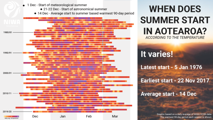
While both the astronomical and meteorological definitions are valid, NIWA forecasters have turned to Mother Nature’s weather patterns, looking at the warmest 90-day period of the year to provide another perspective on when summer in Aotearoa New Zealand begins.
And it turns out, the date varies considerably.
It has started as early as 22nd Nov in 2017 and as late as 5th Jan in 1976. On average, when summer is defined in this way, it begins on14th December.
]” title=””>
Have our summers been starting earlier?
“While summer start dates jump around when looking at the warmest 90-day period every year, no clear trend is emerging that summer is getting earlier or later. The summer period is getting hotter though - an expected result given our warming climate,” says Ms Fedaeff.
In some Scandinavian countries, “thermal seasons” are used. For example, the beginning of summer is defined as when the temperature permanently rises above a certain threshold for several consecutive days. This method gives a dynamic response to the natural world and can be used in practical ways, such as in the farming industry when irrigating crops.
“If we defined seasons like that here, then we would see an earlier start and later end to summer, with our shoulder months warming due to climate change”, says Ms Fedaeff.
What about this summer?
“We have got off to a very warm start. December is currently on track to be in our top ten warmest on record, but it has also been very wet in places and some may argue that is not that summer-like at all,” she says.
Despite the wet start to the month, the forecast for the Christmas and New Year period is shaping up to be a bit merrier and brighter.
High pressure will more commonly span across the country, likely influencing more dry days than wet ones for most regions.
Where will have the best weather on Christmas Day?
“The warmest weather looks to be in the northern and western North Island. The eastern South Island will have low clouds, particularly during the morning, and cooler than average temperatures,” said NIWA meteorologist Ben Noll.
“An onshore wind flow will bring some extra clouds and prevent a hot Christmas in the eastern North Island,” he said.
Warmer than average coastal sea temperatures in New Zealand and the Southwest Pacific means that NIWA forecasters will be keeping a close eye on the tropics right through the season. While no tropical cyclone development is expected in the near future, that could change early in the new year.


