Source: University of Waikato
University of Waikato researchers who have been investigating newly-discovered faults in the Hamilton Basin say a fault uncovered near Morrinsville may have also impacted the Hamilton area.
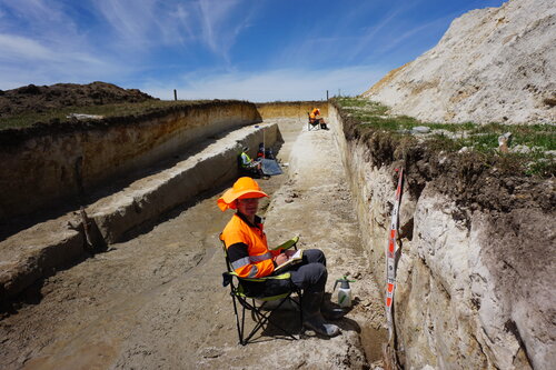
Professor David Lowe and others in his team are working on a joint project, led by GNS Science and funded by EQC, investigating newly-identified Te Puninga Fault near Morrinsville.
His team of researchers has also been working to uncover Hamilton’s seismic history by analysing liquefied layers of volcanic ash preserved within sediments that accumulate at the bottom of lakes and using them to identify earthquake activity.
“Te Puninga Fault is the closest one to the Hamilton Basin, which we have been focused on, so we are now also trying to work out if activity on Te Puninga Fault may have impacted on the Hamilton Basin, and when.”
Professor Lowe says the University was helping to analyse samples from Te Puninga Fault to date when it was active. Field work suggests the fault has been active (generating earthquakes) in the past 24,000 years and preliminary observations suggest it may have moved within the past 2,000 years. Dating being undertaken will test that and other possibilities. His team’s work in the Hamilton Basin suggested one or more of those faults had been active several times at least within the past 20,000 years.
The work is driven by findings from the Christchurch Earthquake inquiry, which required regions to find hidden faults and better understand the hazards and risks associated with them.
“The risk of earthquakes in our region today is no greater than it was before we discovered the faults but it is just that now we know more about it,” says Professor Lowe.
His team is using a range of dating methods to determine when Te Puninga Fault was active, including radiocarbon dating, luminescence dating, which examines when mineral grains in samples were last exposed to sunlight, and tephrochronology, which uses layers of volcanic ash of known age as a special way of dating the trench sites.
In their work on the Hamilton Basin the Waikato-led team has been taking cores from lakes in the area, their aim being to core up to 30 lakes. They identify the layers of ash in the sediments that were deposited during volcanic eruptions. Using a CT scanner at Hamilton Radiology, they have then identified signs of liquefaction within those ash layers that point to seismic activity. Liquefaction, where sediment turns to liquid, was a predominant feature of the Christchurch earthquakes.
“A key finding to come out of the inquiry into the Christchurch Earthquake was regions needed to find and better understand any hidden faults. Our work in the Hamilton Basin is a result of that.”
“Hamilton is currently classified as having a low to moderate earthquake risk; but our research will inform future understanding. What we find could impact local building codes and where people can develop in the future,” says Professor Lowe.
Professor Lowe says the University attracted Marsden Funding and funding from the Ministry of Business Innovation and Employment to carry out the research in the Hamilton Basin, carrying some of that funding over into the joint project on Te Puninga Fault, alongside GNS and EQC. Researchers from the University of Auckland, Swansea University and GNS were also involved in the Hamilton project, and support from Waikato Regional Council, Hamilton Radiology, and local iwi including Ngāti Wairere was acknowledged.


